

Words Fail
Science, policy, and theology in the face of unimaginable loss

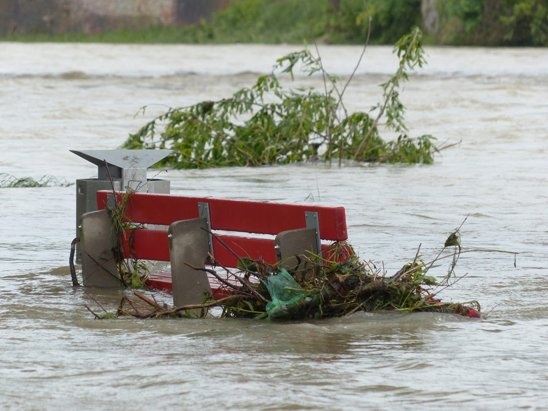
As you have likely heard, a devastating flash flood swept through the Texas Hill Country in the early morning hours of July 4. At this time, we know of nearly seventy people who lost their lives in the flood. The situation continues to develop and the communities affected will never be the same. Our prayers, along with our cries of lament, are with the families and loved ones of those affected.
What is flash flooding?
Flash flooding is a meteorological term that describes a rapidly-forming flood. In contrast to other kinds of floods that form over days or weeks, flash floods can form in hours to minutes, making them an extremely dangerous weather hazard.
What is Flash Flood Alley?
Many factors come together in the Texas Hill Country to make the region especially vulnerable, which is why the region is sometimes referred to as “Flash Flood Alley”. Flash Flood Alley stretches from the San Antonio area up I35 to Dallas and to the west towards communities like Burnet, Mason, and Kerrville.
Several geologic features make the region vulnerable to flash floods. First, the bedrock in the Texas Hill Country is limestone and it is very close to the surface. That thin layer of soil is not able to soak up intense rainfall, so most of it becomes runoff.
Second, hilly topography funnels runoff into narrow stream valleys. Then, the steep valley walls make it so the water rises quickly and flows fast.
Third, the Balcones Escarpment, which runs along I35 from San Antonio to Dallas, forces moisture-laden air coming from the Gulf to rise. This feature acts as a focusing mechanism, which can create clouds and thunderstorms.
In addition to these geological features, Central Texas can have really intense rainstorms in the late spring and summer. This time of year we look to tropical cyclones as a cause of intense rainstorms in Texas. This weekend’s storm was caused by several factors, the remnants of Tropical Story Barry was one of those ingredients.
The final ingredient that makes the region so flood-prone is the warm Gulf, which supplies lots of moisture to the atmosphere that can then fall as precipitation. The warmer the water in the Gulf, the more moisture available to storms on land.
That warm, moist air paired with the upper level features caused by Tropical Storm Barry and a decaying complex of thunderstorms that moved north out of Mexico at the same time created perfect conditions for the extremely intense rainfall that fell near Kerrville on July 4.
Who warns the public about weather hazards?
Multiple offices within NOAA work together to warn the public about weather hazards. The National Weather Service is responsible for issuing forecasts for weather several times a day, around the clock, every day of the year. Offices are staffed twenty-four hours a day to ensure continuous weather coverage. Each National Weather Service office has a warning coordination meteorologist who specializes in issuing watches and warnings when severe weather is imminent or occurring.
The National Weather Service is supported by the Storm Prediction Center. These meteorologists specialize in severe thunderstorms that cause hazardous weather like hail, damaging wind, tornadoes, and extreme precipitation. Within the National Weather Service the Advanced Hydrologic Prediction Service also helps support flash flood monitoring, prediction, and warning.
Operational forecasters at the National Weather Service benefit from the state of the art science and research which comes from the NOAA agencies like the National Severe Storms Lab and the National Weather Hydrology Laboratory. These multi-layered and interactive system of labs and operational forecast offices make NOAA a world-class scientific organization that has improved forecasts and understanding of all kinds of weather hazards.
Who helps the public respond to the threat of flash flooding?
In the event of a weather hazard like flash flooding, the National Weather Service works closely with emergency management personnel at the city, county, and state levels. They advise one another on the need for evacuations based on a combination of expected conditions and specific local needs. Emergency managers are responsible for maintaining plans and criteria for evacuations for a variety of weather threats and are aware of specific facilities which require special consideration like nursing homes, hospitals, and critical infrastructure.
After a disaster occurs, local and regional emergency management is supported by the state-level Texas Division of Emergency Management and the Federal Emergency Management Agency, FEMA, helps coordinate disaster response and recovery in the form of coordination, recovery, and funding.
Did the system work as it was supposed to for this event?
In response to questions about whether this event was adequately warned by the National Weather Service, Matt Lanza does a good job explaining the evolution of the forecast. As the event got closer, forecast rainfall totals increased as confidence from computer models increased; warnings about intense precipitation and the potential for flash flooding were issued appropriately. This includes multiple mentions of flooding potential in forecast discussions, a flash flood watch, flash flood warnings, and a higher level “Flash Flood Emergency” warning that was issued for Kerr County just after 5:00 AM on July 4. This type of warning is reserved for only the most dangerous events.
Texas Division of Emergency Management announced that it was activating state emergency management resources due to the threat of flooding on Wednesday, July 2. A social media post by NPR reports that TDEM made contact with local officials in the affected area to warn them about the potential for flooding.
Every forecaster will tell you that part of the job is to evaluate where improvements can be made. That work is already an ongoing part of the operations at NOAA, which is why loss of life from weather hazards has declined so much in recent decades.
Even given our very good infrastructure, sometimes an event is worse than even forecasters and forecast models can anticipate. Meteorologist Matt Lanza said “We need to understand the limits of predictability in these scenarios. Models often tell us about the potential for a high-end event. But in Texas in particular the specific placement of a high-end event is extremely tough to pin down. A few miles makes a world of difference…”
The complex of thunderstorms that dropped up to twenty inches of rain in Kerrville this weekend is the worst-case scenario, made worse by the fact that it happened in the middle of the night on a holiday weekend when hundreds of people had traveled to the Hill Country for vacation.
It is human nature to respond to our own pain and fear by searching for someone to blame after a natural disaster. But many accounts suggest that this storm simply exceeded our ability to anticipate its severity.
What do we do now?
The time will come to talk about policy solutions that might prevent or mitigate a similar disaster from happening in the future. Conversations about early warning systems, emergency communications, and funding for emergency response and weather monitoring at all levels of government are starting to happen even now. These are a needed and compassionate response.
It is also appropriate for those of us who do not hold access to the levers of power to take a moment to grieve. It is difficult to comprehend the scale of the loss of life. It is natural to wonder why bad things happen. There are no easy answers. There is little to reassure us. In my tradition we remind each other that God is with us, always, and most especially when we are hurting, that God hurts when we hurt.
The most helpful response in this moment is to turn towards our loved ones and our communities, to be helpful where we can, to pray, to contribute financially if we are able, and to err on the side of love and compassion in our thoughts, words, and actions.
A Prayer for After the Flood
God of Creation and Love who hurts when we hurt,
Our hearts break with the people of the Texas Hill Country.
A place where so many feel a spiritual connection to the beautiful scenery, the rocky creeks, and the cool, clear water has turned into a place of chaos and danger without warning.
Our spirits feel heavy and tender as we learn of the loss of children, friends, and family members. It feels unbearable. Such loss is senseless, but we know that God is with us, always.
For those who grieve loved ones, give them comfort;
For those who are waiting for news, give them peace;
For rescue workers, give them strength;
For helpers, volunteers, clergy, faith leaders, and medical personnel, give them energy and resilience.
The needs are so great right now. It is hard to know where to start.
Give us wisdom and discernment. Give us strength for the long road to recovery.
Be with our siblings who are facing the unimaginable. Help us know how to help them.
Strengthen our communities, grow our understanding, and give us all peace.
Amen.
This is the clearest explanation I have ever read of how flash floods happen, and specifically this flash flood. I feel like I actually understand it now. Also, it is a most balanced expression of science, faith, and compassionate action. I think it should be required reading for all legislators and everyone who cares about policy and justice. Thank you, Becca!